'Ground Zero' of Climate Crisis
"The Northern Triangle"
The Northern Triangle of Central America (NTCA), a region comprising Guatemala, Honduras, and El Salvador, is “ground zero” for global warming’s impact in the Americas. The global climate crisis on the region, including drought, floods, increasing temperatures, and rising sea levels have implications for the NTCA’s human and social development, and has increased the internal and external migration.
The least contributor to global carbon emissions yet the most impacted
Climate Change is causing a growing humanitarian crisis in a region already wracked by poverty, inequality, and violence—and one which bears little responsibility for climate change, contributing less than 1 percent of global greenhouse gas emissions. The average temperature in Central America has increased by 0.5C since 1950; it is projected to rise another 1-2 degrees before 2050. This has a dramatic impact on weather patterns, on rainfall, on soil quality, on crops’ susceptibility to disease, and thus on farmers and local economies.
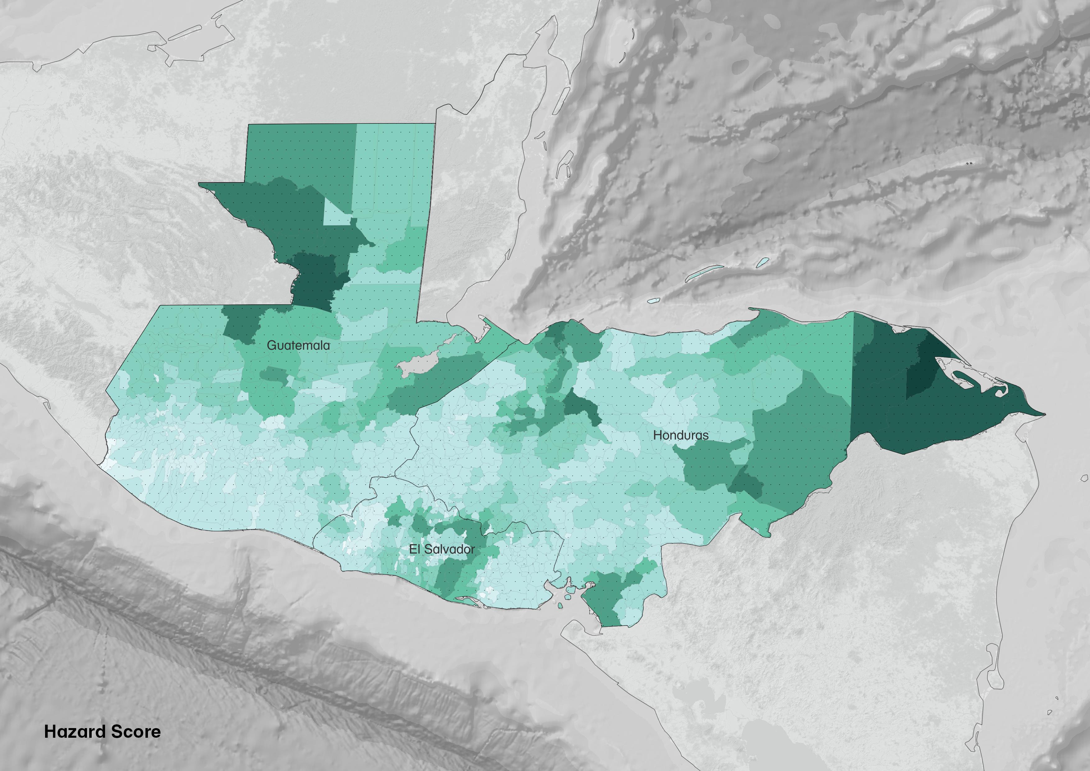
The map shows flood prone areas. Demonstrating the risk by meters from lighter to darker, between 3 and 7 meters. Data Source: ARCGIS Flood Hazard 2015.
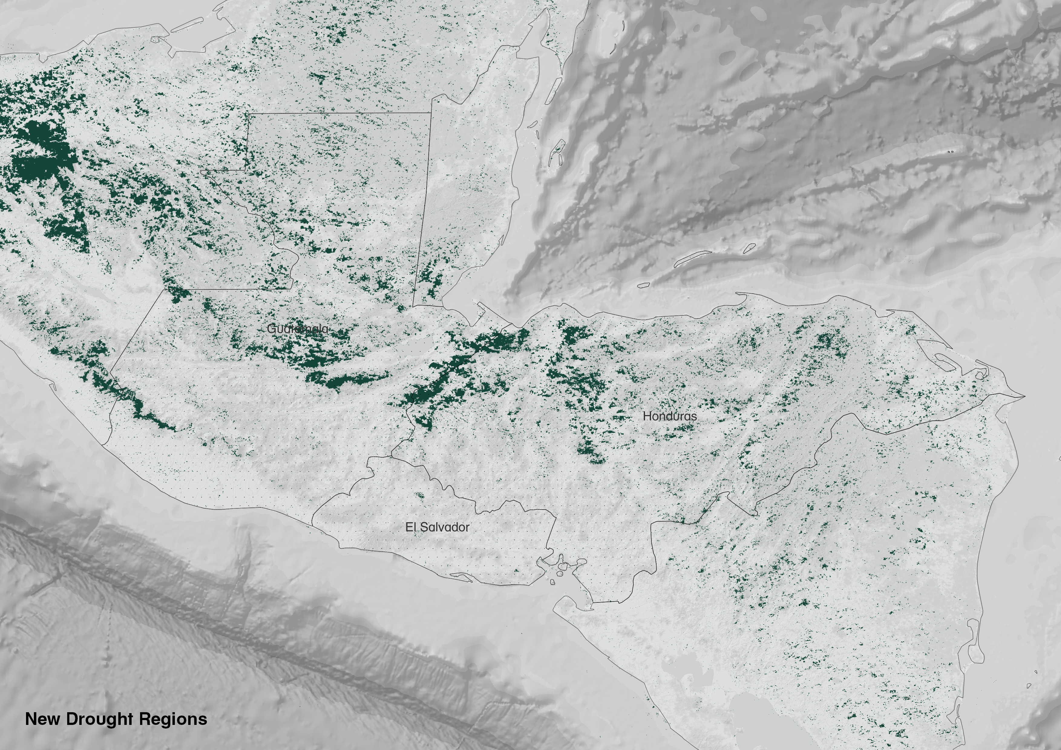
The map shows the new drought regions in the Northern Triangle in the last five years. Data Source: ARCGIS Increased_Drought_Regions (Map Service)
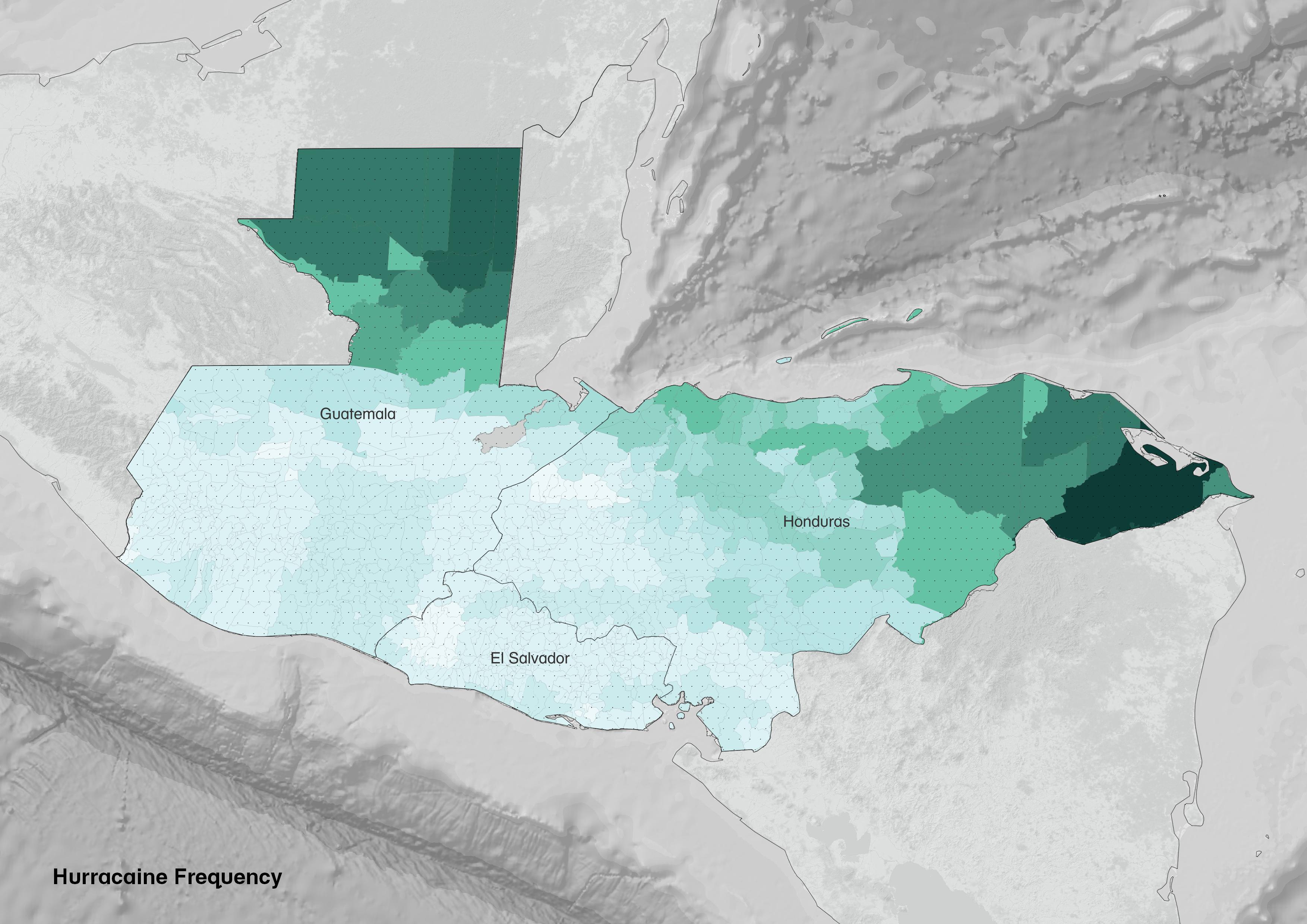
This map shows Hurracaine frequency. Demonstrating hurracaine frequency from lighter to darker. Very low risk (0 hurracaines), Low risk (1-4 hurracaines), Medium risk (5-8) hurracaines) High Risk (9+ hurracinines). Data Source: WFP Natural hazard analysis.

Future predictions: According to the US Agency for International Development, countries in the northern triangle will see decreased rainfall and prolonged drought, writ large. In Honduras, rainfall will be sparse in areas where it is needed, yet in other areas, floods will increase by 60%. In Guatemala, the arid regions will creep further and further into current agricultural areas, leaving farmers out to dry. And El Salvador is projected to lose 10-28% of its coastline before the end of the century. How will all those people survive, and where will they go?
.
The 'Hot Spot' of climate crisis
Honduras
Honduras is predicted to become a climate 'hot spot', or an area that sees relatively more intense effects of climate change, with greater temperature increases than the rest of Central America. These shifts could challenge the Honduran agriculture industry, which employs almost one-third of the population. The rural poor overwhelmingly depend on rainfed agriculture as their principle livelihood and are concentrated in the southern and western regions, known as the Dry Corridor, where food insecurity has become a recurrent issue; 58 percent of children under five suffer from chronic undernutrition. In urban areas, migration from rural areas and population growth have pushed settlements into hazard-prone zones that lack water management systems, resulting in frequent flooding and water scarcity in major cities and towns. Climate change will increase the frequency and severity of water scarcity and climate-related hazards, and put additional strain on the Honduran government’s capacity to address ongoing development barriers, including extreme inequality, low levels of education, acute environmental degradation, and rampant crime and violence.
"The ‘spiralling crisis’ pushing Hondurans to flee north BUT is anyone coming back?
The Multi-Hazard Risk Score was calculated by the World Food Program and incldues three main factors: Droughts, Floods, and Tropical Cyclones by municipality. The severity of each of the three was classified into four categories from 0-3, using Jenks Natural Break Classification. The multi-hazard risk score added the score for Drought, Flodods, and Tropical Cyclones. In addition, the World Food Program utilized the return rate for their research on the relationship between natural hazards and migration.
In Honduras, with hurricanes and other extreme weather events becoming ever more powerful and frequent, increasing numbers of people in Honduras are having to flee their homes. The map indicates geographical areas of honduras that have been most impacted by extreme natural events and understand their correlation with migration flows (data source: WFP, 2021). The migration flows indicates the number of people returning per municipality. The map reveals that the percentage of people returning to safer Municipalities is higher than in Municipalities with extreme climate risks. This could br one way to percieve the picture, where people of Honduras are likely to return if environments are safer and resilient.
Are all livelihood equally impacted by Climate change?
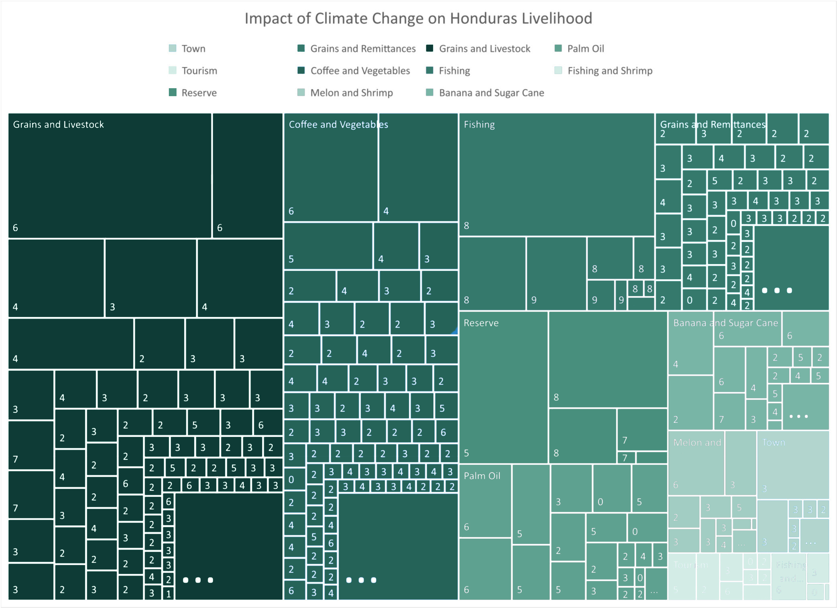
According to Famine Early Warning Systems Network (FEWS NET), Honduras has 11 major livelihood sources. The diagram illustrates the impact of climate change on Livelihood Zones in Honduras by area. The reading of visualization by area reveals that harvesting grains, livestock, coffee and horticulture are widely practiced followed by fishing, palm oil and so on. Although fishing has a moderate dependency on livelihood, it is largely impacted by changing climate, followed by cultivation of grains and coffee.
Case Study: Cortes, Honduras - A Picture of Climate Migrants
Using the data from the World Food Program, we were able to compile data on households who expereinced different types of natrual hazards. We wanted to speficially show the natrual hazards experienced by households of Cortes in Honduras, as it is the most populated Department in Honduras and we saw that Honduras had a higher climate risk score, as seen in the WFP Climate Analysis compared to the other Northern Triangle countries. The map below shows the amount of households interviewed in each municipality in Cortes that were affected by natural hazards. We also looked at households within Cortes who selected that they were migrating due to direct impact of natural hazards or deterioiration of life due to natural hazards and looked into some characteristics of these climate migrants.
Climate motivations for migration may be underrepresented in the data
What is next?
In the chart below, you can see that the vast majority of people who were affected by natural hazards chose to migrate to find a better job, salary, or working condition. Not many chose that they were planning to migrate due to the natual hazard risk. However, it is possible the climate motivations for moving are underrepresented in the data. As seen below, the vast majority of households intereviewed that experieneceed natural hazards lived in rural areas. For many people in rural areas, their livelihoods are tied to agriculture and the lack of harvest for agriculture may not be obvious as a climate issue for many as they may consider it more of an economic issue. As climate risks increase, many more households may be forced to migrate to make their livelihoods.
Acknowledgements
This website was development by Gabriela Degetau, Shivali Gowda and Mona Vijaykumar
Bibliography
"https://hub.arcgis.com/"
https://tiles.arcgis.com/tiles/ooPFIStaL7CL8egb/arcgis/rest/services/Increased_Drought_Regions/MapServer
https://climateknowledgeportal.worldbank.org/country/guatemala/vulnerability
https://climateknowledgeportal.worldbank.org/country/honduras
https://sites.tufts.edu/gis/files/2016/01/Mazariegos_Alejandra_DHPP207_2016.pdf
https://data.humdata.org/dataset/honduras-admin-level-1-boundaries
Livelihood data: Famine Early Warning Systems Network (FEWS NET)
WFP Survey (June 2021) - Main Table, Migration Ext Roster, Household Roster
WFP Natural Hazards Analysis - Honduras Multi-Hazard Score, Honduras Migration Retornos Points
"https://hub.arcgis.com/" https://tiles.arcgis.com/tiles/ooPFIStaL7CL8egb/arcgis/rest/services/Increased_Drought_Regions/MapServer https://climateknowledgeportal.worldbank.org/country/guatemala/vulnerability https://climateknowledgeportal.worldbank.org/country/honduras https://sites.tufts.edu/gis/files/2016/01/Mazariegos_Alejandra_DHPP207_2016.pdf https://data.humdata.org/dataset/honduras-admin-level-1-boundaries Livelihood data: Famine Early Warning Systems Network (FEWS NET) WFP Survey (June 2021) - Main Table, Migration Ext Roster, Household Roster WFP Natural Hazards Analysis - Honduras Multi-Hazard Score, Honduras Migration Retornos Points